
Walk 1 - The Salt Pans and Paradisos
Walk 2 - The Chapel at Agios Louka
Walk 3 - Round the back of Mavrikiano
Walk 4 - As walk 3 but via the cemetery
Walk 5 - Across the foot of Oxa by Elounda Residence
Most of these walks are suitable for mountain bikes too. A note will be made where the terrain is dodgy for bikes. Always wear suitable footwear and clothes (subject to the weather conditions) and carrying plenty of water is advisable in summer. On the shorter walks I like to save my thirst for one of the watering holes on the route (see maps or text). Times given are approximate based on me doing the walks out of season so allow more time in the heat of the season! If you meet a local whilst walking always say 'Yassas' (yahsas - hello) or Kali mera (kali mehra-good morning). I hope these walks give you a different perspective of Elounda.
(Thanks to Gordie for showing me some of these paths)
Walk 1 The Salt Pans and Paradisos
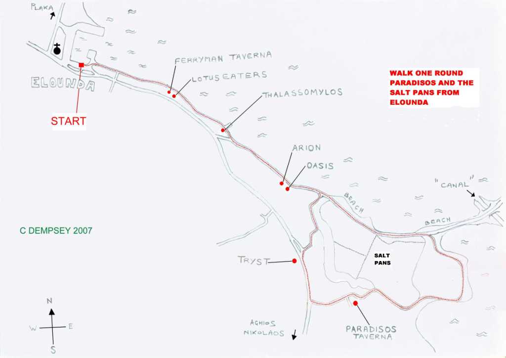
Start at the harbour car park pavement opposite the central kiosk (next to Nikos Fish Taverna). With the sea on your left walk out of Elounda following the 'coast road' through the beach side tavernas. In a few minutes the road becomes a dirt track adjacent the Lotus Eaters {Daniel & Oksana} (just after the Ferryman's Taverna - the one featured in the TV drama). Follow this dirt road and at the end pass through the Thalassomylos (mill by the sea) Taverna onto the Causeway. (There is a right of way)
With the sea on your left stay on this road passing (or stopping) at a few bars (Arion {Arion & Anna}, Oasis {Gwyn & family}, Hiona et al). You'll pass these again on your return journey so no sweat. Carry on past the old salt pans on your right and a beach on your left until you reach a few trees and a dirt road branching to the right just after a bench. Take this road through the area called Paradisos. With the sea still on your left, you will have views towards the old canal bar and then as you round the corner, views of the big hotels with the road to Aghios as a back drop. The salt pans will now be on your right as the dirt road eventually becomes a gravel track. A left turn slightly rising takes you past the Taverna Paradisos (on your left); handy if you need refreshment. Staying on the gravel road will soon take you to the main Elounda/Aghios Nikolaos road.
At this junction turn right back towards town. After a few minutes you will pass (or stop at) the Tryst on your left, another opportunity for drinks and/or food but with Scots ambience {Jim & Elaine}. Just after the Tryst a small road branches to the right behind some buildings; take this then turn right again down a path which will take you back to the Causeway skirting the salt pans on your right.
From here retrace your steps back to Elounda having a second chance at drinks or mezedes at the afore mentioned bars. I hope you enjoy the stroll.
Walking time without stops approx. 45 mins. Distance approx 2 miles/3 k. Easy going, no climbs. Warning - many bars.
Where names are given it is because I have used those places. Living here there a too many bars to frequent (without becoming an alcoholic!) so other establishments may well be worth a visit - let me know your experiences.
Back to the top of the page
Walk 2 The Chapel on the Island - Ag Louka


Start as walk 1 for the first 15 mins (approx.) but don't leave the Causeway at Paradisos, stay on the road and cross the canal on the bridge by the old windmills.(A Basilica is signposted to the right if you have an archeological bent, it's only minutes away)


Follow the dirt road (the sea is on your left) until you come to a right turn with a little sign on the wall indicating Ag Louka (AG LOUKA) just before Elounda Island Villas (your last refreshment spot, open to non-residents). Take this right turn and follow the track up the hill to the top (about 20 mins). You should be able to see the chapel from here (you can't miss the flags). Keeping left, a few metres in front of you is a paved walkway which leads up to the chapel. Enjoy the views down towards Bird island (Kolokitha*). If you want to explore there is a path behind the chapel which leads up the hill side but be careful of your footing and watch out for the spiny shrubs (spina-longa). Just retrace your steps for the return journey back to Elounda.
If you have time there is a track which leads down the hill, eventually becoming a path which ends at a lovely beach. The only downside of this beach is that it is used by the barbecue boats from Aghios Nikolaos and can get busy. You can see if the boats are in before you start your descent.
Walking time (excluding descent to beach) without stops approx. 1 hour 15 mins. Distance approx 3.5 miles/6 k. Easy start, long but gentle climb then it's all downhill!
* There is some controversy over the names of the islands off Elounda. Some say the big 'island' is called Spinalonga, the same as the Venetian fortress island (leper colony) whilst others call it Kolokitha. However the small island seen from the chapel looking east is also called Kolokitha and/or Bird Island.
Back to the top of the page
Walk 3 Round the back of Mavrikiano
Starting from the harbour walk to the left of the clock tower taking the road towards Pano Elounda (ie. the opposite direction to Agios Nikolaos). Take the second turn on the right (opposite the Olive Grove Appartments) just a few metres out of town. Follow this road past the hardware store and after a few hundred metres take the right turn into the lane with the No Entry signs (see photo). This is Odos (road) Elyti.

.JPG) The lane sweeps to the left then rises towards
Mavrikiano. At the next junction between the school and the nursery take the
right fork up the hill (Walk 4 goes left here).After a short but moderately
steep climb the road splits. Take the concrete road directly ahead (if you
already fancy a drink the other road climbs steeply to Mavrikiano where,
at the top, you will find two kafeneia, the Panorama and Hope bars which have
excellent views at the back). The concrete road takes you round the back of
Mavrikiano with views on your left towards the cemetery (where Walk 4
leads).
The lane sweeps to the left then rises towards
Mavrikiano. At the next junction between the school and the nursery take the
right fork up the hill (Walk 4 goes left here).After a short but moderately
steep climb the road splits. Take the concrete road directly ahead (if you
already fancy a drink the other road climbs steeply to Mavrikiano where,
at the top, you will find two kafeneia, the Panorama and Hope bars which have
excellent views at the back). The concrete road takes you round the back of
Mavrikiano with views on your left towards the cemetery (where Walk 4
leads).
 Stay on this road heading north, rising slightly apart from a short
climb as the road swings left then climbs to the right (Walk 4 joins from the
dirt road on the left between these 2 turns). After the crest of the hill the
road becomes a dirt road and you start to descend. The bay is now visible on
your right and soon you will see Spinalonga directly ahead. Be careful on the
final stretch which is a steep concrete road usually covered with loose gravel.
At the bottom turn right back towards Elounda (going left will take you to
Plaka). There is a pavement on the left all the way into town which will take
you about 25 minutes unless you stop at one of the many bars and tavernas on the
final stretch (The Sea Breeze, Avli, Elenes, Bar Bee, Rudi's to name just a
few).
Stay on this road heading north, rising slightly apart from a short
climb as the road swings left then climbs to the right (Walk 4 joins from the
dirt road on the left between these 2 turns). After the crest of the hill the
road becomes a dirt road and you start to descend. The bay is now visible on
your right and soon you will see Spinalonga directly ahead. Be careful on the
final stretch which is a steep concrete road usually covered with loose gravel.
At the bottom turn right back towards Elounda (going left will take you to
Plaka). There is a pavement on the left all the way into town which will take
you about 25 minutes unless you stop at one of the many bars and tavernas on the
final stretch (The Sea Breeze, Avli, Elenes, Bar Bee, Rudi's to name just a
few).Walking time approx. 50 mins, distance 2.5 miles/4 k. Another easy walk with a steady climb at the start for about a third of the distance. Walk 4 is the same walk but with more climbing and hence better views.

Walk 4 - Round the back of Mavrikiano via the cemetery
Start as Walk 3 until the junction at the school/nursery. At this point turn left and follow the lane round to the right and (see 1st photo) take the lane to the right of the Mavrikiano sign. Follow this path (2nd photo) rising slightly until the lane forks (see 3rd photo as the path to the right is not obvious). Take the right fork along the narrower lane which is quite overgrown with small trees. After a short distance it joins a tarmac lane; turn right here. The lane starts to climb steeply with a stepped wall (ideal seating on hot days!) on the right. Ignore the concrete road directly ahead and turn right, this is the final approach to the cemetery.
.JPG)
.JPG)
.JPG)
The route of the walk leaves this road before the cemetery but it is worth the extra distance to visit the cemetery for the excellent views across Elounda and also to admire the cemetery itself. (20 mins to here)
.JPG)
.JPG)
.JPG)
From the cemetery walk back down the hill to the wooden electricity pole (see photo) which will be on your left (or on your right if you have not visited the cemetery).
.JPG) Take the stoney path (between
the pole and the small grate) which drops diagonally down the hill,
skirting the shrubs which have overgrown the start of this section. After a
short distance the narrow path becomes a wide dirt road. Follow this road down
the side of the hill which has views of the back of Mavrikiano (and Walk 3) on
the right. After about 15 minutes (from the cemetery) the dirt road ends
at the concrete road which Walk 3 follows. Turn left here up the
hill, the concrete road swinging to the right and soon becoming a dirt road
again. Follow directions for Walk 3 (you can check the map for where the walks
converge) to complete the walk back to Elounda and a refreshing drink!
Take the stoney path (between
the pole and the small grate) which drops diagonally down the hill,
skirting the shrubs which have overgrown the start of this section. After a
short distance the narrow path becomes a wide dirt road. Follow this road down
the side of the hill which has views of the back of Mavrikiano (and Walk 3) on
the right. After about 15 minutes (from the cemetery) the dirt road ends
at the concrete road which Walk 3 follows. Turn left here up the
hill, the concrete road swinging to the right and soon becoming a dirt road
again. Follow directions for Walk 3 (you can check the map for where the walks
converge) to complete the walk back to Elounda and a refreshing drink!Back to top of page
Walk 5 Across the foot of Mount Oxa by Elounda Residence
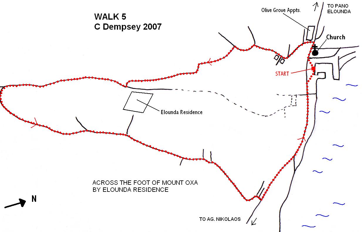
Leave the harbour car park by the clock tower heading towards Pano Elounda but take the first turn left at the Olive Grove Appartments. Follow this road until it becomes a gravel track after which it soon forks; take the left fork which soon swings to the right where the road becomes more of a donkey track. (Staying on this track will eventually take you to the concrete/dirt road which climbs towards Oxa). However we are not going that far. After a few hundred metres there is a rocky area on the left where a path starts to climb upwards. A yellow sign nailed to a tree indicates the start of this path (see first photo). The path is not very evident at first but soon appears after a short climb (mountain bikers will have to carry their bikes at this point).
Follow the path up the hill, after a short distance it soon widens and becomes a dirt road. At this point you can turn round for an excellent view of Elounda and the bay (2nd photo). The dirt road skirts a small olive
.jpg)

 (448 x 336).jpg)
 (448 x 336).jpg)
grove on the left then doglegs before beginning to climb up the hill to Elounda Residence (the buildings visible in the distance ahead of you) the last part of the road being concrete (see photo 3). At the top of this concrete stretch there is another concrete road; turning left will take you back down to Elounda but we're going right up the hill :-) Before we do this just cross the road for another good view (photo 4) looking towards the mountains above Mochlos and Kavousi.
Continue up the hill, the concrete road soon becoming a dirt road with Mount Oxa on the right and a panoramic view of the salt pans and big Spinalonga Island on your left (assuming you're not walking backwards). Ten minutes later you should be at the highest point in the walk (approx half an hour since leaving the harbour). The road gently descends and swings to the left, adjoined by a chain link fence (photo7). There is now a 25 minute stroll down to the main Elounda/Ag. Nikolaos road (after 10 mins the concrete road joins a tarmac lane, just keep straight on). At the main road turn left for a 10 minute walk back to the harbour. There are a number of bars and tavernas on this stretch if you need to slake your thirst.
 (448 x 336).jpg)
 (448 x 336).jpg)
 (448 x 336).jpg)
 (448 x 336).jpg)
Walking time approx. 1 hour 10 mins, distance just under 3.5 miles/5.5 k. A long steady climb with the usual good views, the descent being slightly steeper. An easy walk.
Click the walker to return to the Crete Menu ...
